


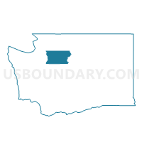
Priest Point Voting District, Snohomish County, Washington
About
Outline

Summary
| Unique Area Identifier | 688820 |
| Name | Priest Point Voting District |
| County | Snohomish County |
| State | Washington |
| Area (square miles) | 0.29 |
| Land Area (square miles) | 0.29 |
| Water Area (square miles) | 0.00 |
| % of Land Area | 100.00 |
| % of Water Area | 0.00 |
| Latitude of the Internal Point | 48.03328730 |
| Longtitude of the Internal Point | -122.23601540 |
Maps

Graphs
Select a template below for downloading or customizing gragh for Priest Point Voting District, Snohomish County, Washington


Neighbors
Neighoring Voting District (by Name) Neighboring Voting District on the Map
- Tulalip 2 Voting District, Snohomish County, WA
- Tulalip 5 Voting District, Snohomish County, WA
- Water: Possession Sound, Snohomish County, WA